Sunday, September 30, 2012

A ride around the Deepings: Returning from Ely

Thursday, 6th September 2012: This is the seventh part of my ride around The Deepings, it started with Part1: Planning a ride around the Deepings, followed by Part 2: Getting There from Peterborough Station, Part 3: 1st Leg Glinton to Crowland, Part 4: 2nd Leg – Crowland to Spalding Part 5: 3rd Leg – Spalding back to Glinton and Part 6: Returning to Peterborough Railway Station – the long way. This covers the return back from Ely Railway Station. The main reason I have broken the Posts about the ride into sections is because it makes it easier to get the Posts written – all in all I selected 69 pictures for inclusion in the posts.

Having arrived back at Peterborough Station, somewhat later than I had anticipated I seemed to have hit a rush hour – which should have been earlier. A quick look on the Information Boards as i entered the station shows that a train was leaving about now on a platform far away. Well it might well have been far away as I would had to run up and down stairs carrying my bike – after finding my ticket and getting through the barriers.

That train was running almost an hour late though!  There were two trains an hour that I could have caught – which one would be most likely to be leaving first? A bicycle does not make it easy to make late platform changes. So I went to the Information desk – which was upfront by the ticket gates and well manned.

They pointed me a a suitable train and said it wouldn’t be late as the fault that caused the previous late train had been cleared. As there are two Train companies operating trains between here (Peterborough) and there (Ely) I asked whether there would be any problems getting my bike onto the train – “have you booked?” said one who was then corrected by the other who said just turn up. (I decided not to ask about peak and off-peak tickets at this point – why is train travel so complicated?

So I lugged my bike over to Platform 4, I think it was – a platform teeming with people waiting for a late train. Oh dear, even worse two trains seemed to be arriving on Platform 4 at the same time. To make matters worse my train was going to be late and the platform was so thin getting around with a bicycle earned me a lot of hard stares.

Still at least I could get carbs and two litres of fluid – although it was not a super-hot day you do dehydrate quite a lot when cycling and I drink all the liquid I’d been carrying.  Even with another 40Km/25 miles or so to go, it was rather pleasant sitting down in a spare seat eating a sandwich made delicious by my hunger and easing my parched throat. One or two people did move away from me a little – I was rather sweaty as well.

The train turned up, as luck (of the bad variety) would have it the cycle door was up the platform so I barged my way through – hoping there would be a space. The train and Train company was a different one from the one I’d caught that morning and so the cycle provision as different.  It was better – not tucked away in some dark hole next to the toilets but in  a carriage with windows, although the toilets were still close by. I even had a seat right next to my bike. There was already a bicycle there – so I leaned my bike on it and relaxed as the train  seemed to crawl through the countryside to Ely.

In places it did crawl – there were signal faults or crocodiles on the line or some such excuse. By the time we reached Ely is was getting dark. It was a good job I had bought my lights with me,

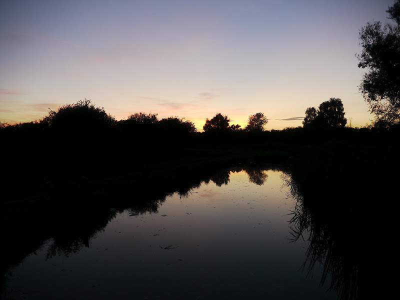
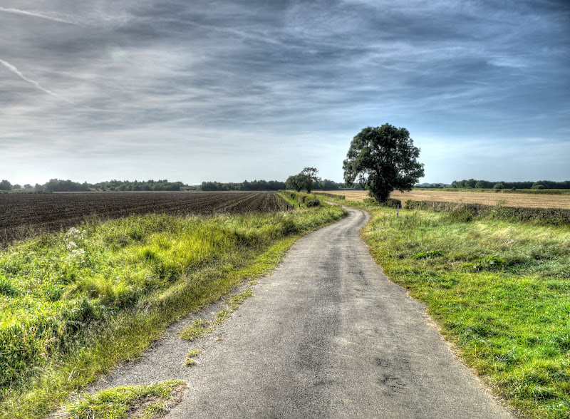
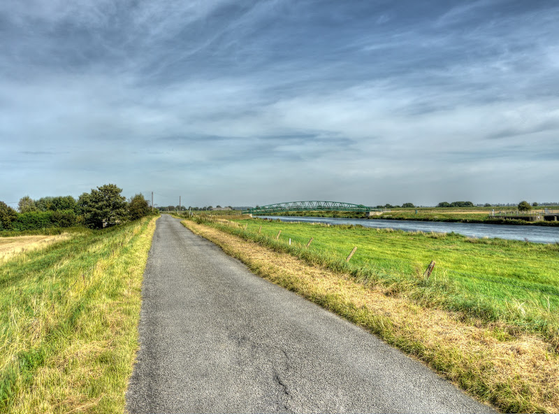
I headed out of Ely along NCN11 alongside the banks of the Great River Ouse – the winds earlier in the day had died down and it made for a pleasant cycle – I didn’t need to put on my windproof jacket.

NCN11, River Great Ouse – Sunset, Ely

I rather like cycling in the dark – especially when there aren’t motorists coming the other way with the lights on main beam trying to blind me. Which is why the NCN11 route from Ely to Lode is pretty good. (The last bit involves cycling alongside a main road until the outskirts of Cambridge.)

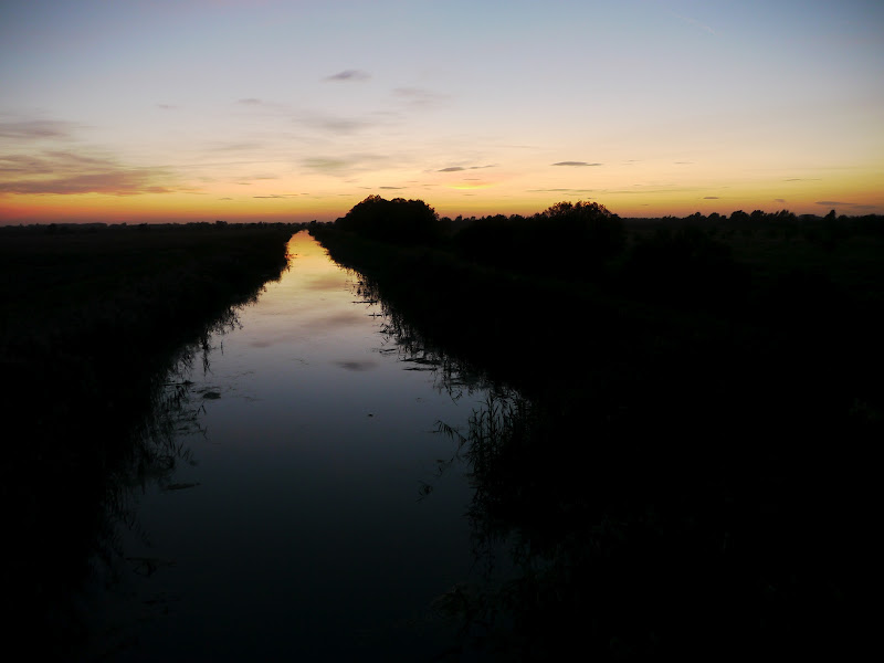
The sun had dipped below the horizon by Wicken Fen and as you can see there was little wind. This is the junction of Wicken Lode and Monk’s Lode just by Norman’s Bridge, over which NCN11 crosses Monk’s Lode.

Wicken Fen, Monk’s Lode – Wicken Lode junction

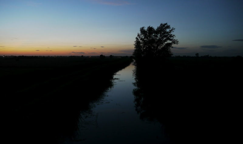
I heaved my bike over the footbridge used to cross Burwell Lode, stopping to take the picture, and then I set off along a deserted Lodes Way. I even turned off my front light whilst cycling in the middle of the Burwell Fen. It isn’t that difficult to see a what is around you and you get to see the sky around spreading out to the stars. I am not quite sure of the legality – since it is not actually a public road – I left my rear lights on though. I picked up this idea from MikeC – one of the things you realise when cycling along Lodes Way is how small this Fen area is as you can readily pick out the settlements around it such as Reach/Burwell/Upware by the street and house lights and they are not that far away.

Burwell Lode from the Footbridge

By the time I reached Reach Lode I had to rest my camera on the bridge to keep it steady. if you look closely you can see the dots from street and house lights on the left of the picture – just below the horizon.  This picture was taken with and exposure time of 0.25seconds (and ISO of 400) so there was a bit of light around still. The camera lens was set to its minimum zoon (14mm – 28mm in35mm speak). The other odd thing about the picture, but not really, is how small the file size is – 1Mb versus a normal size of 4-6Mb. The answer is simple really there is not actually a lot in the picture apart from shades of black and a tinge of orange so with JPEG compression it is quite small.

Elsewhere I waffle on about how many pictures that made it into the Post – well it wasn’t until writing this post that I realised that this picture below hadn’t even been downloaded.

Reach Lode

For one last time here is the map of my ride starting in Peterborough, I cycled to Ely from Cambridge and caught the train to Peterborough. However you could catch a train from Cambridge to Peterborough or even to Spalding Spa Here is the Bike Route Toaster link to that map, the route as marked is 82Km/51 miles in length. The Cambridge/Ely ride added another 50Km or so onto the ride.. If you have followed the legs there is ample scope to cut the ride down either by using different stations Cambridge to Spalding Spa for instance or by taking more direct routes.

There will be a next time as I really enjoyed exploring pastures new. The Peterborough Green Wheel is a very impressive collection of rides in and around Peterborough which itself would make for a pleasant day’s exploring. I would also like to visit Crowland, Spalding and Market Deeping the next time as well.

I was also very impressed with places like Ferry Meadow in Peterborough. It is easy to consider Cambridge as the exemplar of cycling cities – well I for one though Peterborough does pretty well. Perhaps that is not so evident because they also have some pretty big roads or parkways as they call them.

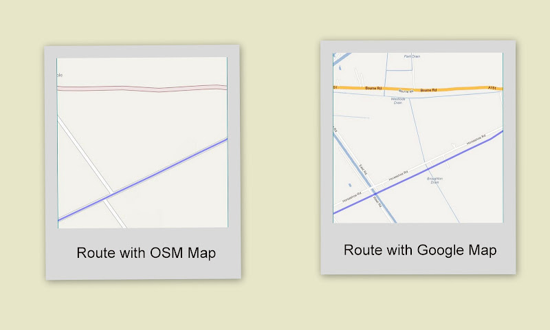
A note of caution is that no maps are perfect and as I pointed out  I only realised when writing this series of Posts that Deeping St Nicholas has yet to make it onto the OSM map. I have to come to pretty much believe in the OSM maps so to have a missing village is surprising – but a reminder that no maps are 100% – certainly the OS maps aren’t.

I have also noticed that occasionally the OSM and Google maps don’t always agree exactly on road placement. Mind you my GPS can often give different co-ordinates for the same routes on different days. This is most noticeable when I compare my GPS plots for my daily cycle to the newsagents and back. I suppose given the accuracy of the GPS system it is to be expected. Sometimes my GPS unit struggles to “see” the satellites and sometimes I reckon there is an “off” satellite up there as it reports quite a shift in position. I do not set my GPS to lock to roads – because it can get confused when there is a byway next to a road and hops between the two.

I took a printed map of the area – jus tin case my GPS and phone failed me – neither did though.

Map of my ride – well the Peterborough – Deepings bit anyway


A ride around the Deepings: Returning to Peterborough Railway Station–the long way

Thursday, 6th September 2012: This is the sixth part of my ride around The Deepings, it started with Part1: Planning a ride around the Deepings, followed by Part 2: Getting There from Peterborough Station, Part 3: 1st Leg Glinton to Crowland, Part 4: 2nd Leg – Crowland to Spalding Part 5: 3rd Leg – Spalding back to Glinton. This covers the return back to Peterborough Railway Station via the Green Wheel. The main reason I have broken the Posts about the ride into sections is because it makes it easier to get the Posts written – all in all I selected 69 pictures for inclusion in the posts.

This leg of the route was longer than I had planned for or realised- it just seemed too good an opportunity to miss – I picked it because it headed off along NCN21. The length of this bit was 22Km/14 miles and it had a hill in the middle – well alright perhaps not a hill by some standards but for a flatlander like myself 35m is a hill – especially towards the end of a day of cycling, with the wind against me on the way back.

Just before reaching Peakirk and completing the loop I turned down Mile Drove – bit before that I stopped on a Stone Bridge over what I later found out was Maxey Cut part of the network of drains in this part of the world. A quick search on the name and it turns out that earlier this year fish were moved from Maxey Cut as water levels drop. It is 9km (5.5 miles) long.

Maxey Cut from the Peakirk Road

As a quick refresher here is the map of my ride starting in Peterborough, I cycled to Ely from Cambridge and caught the train to Peterborough. However you could catch a train from Cambridge to Peterborough or even to Spalding Spa Here is the Bike Route Toaster link to that map, the route as marked is 82Km/51 miles in length.

I only realised when writing this series of Posts that Deeping St Nicholas has yet to make it onto the OSM map. I have to come to pretty much believe in the OSM maps so to have a missing village is surprising – but a reminder that no maps are 100% – certainly the OS maps aren’t.

I have also noticed that occasionally the OSM and Google maps don’t always agree exactly on road placement. Mind you my GPS can often give different co-ordinates for the same routes on different days. This is most noticeable when I compare my GPS plots for my daily cycle to the newsagents and back. I suppose given the accuracy of the GPS system it is to be expected. Sometimes my GPS unit struggles to “see” the satellites and sometimes  I reckon there is an “off” satellite up there as it reports quite a shift in position. I do not set my GPS to lock to roads – because it can get confused when there is a byway next to a road and hops between the two.

For choice I like to cycle along varying  terrain with varying views. I reckon that gently undulating is the best – you get small hills both and up and down and if there is a bit of woodland around and it is off road so much the better.  I liked my ride around The Deepings but was ready for a change of scenery and I was fortunate enough to get a change of scenery. After Mile Drove the route switched to this track with a tarmac surface. I must have passed Nine Bridges (viaduct) but was more interested in making progress I think.

NCN21 near Nine Bridges (part of the Peterborough Green Wheel)

This route crossed the A15, which looks to be a busy road, fortunately there were gullies – perhaps not suitable for penny-farthings but perfectly serviceable for me.

NCN21 Crossing under the A15 – up and down tubes

After the cross-under yet more traffic-free tarmac – out in the countryside – this is what cycling should be about. The weather was still looking good as well.

NCN21 near the A15 (part of the Peterborough Green Wheel)

Somewhere off to the side was a Church Spire peeping out with straw bales in the field.  I should really have stopped a little earlier to better frame the Church – but at this point there was no going back I still had 50-60Km left of my ride I reckon. I think it was Etton and I was back in Cambridgeshire.

Church Spire – Etton

After that I reached a road and turned South – although for a proper road is was still relatively quite and traffic-light. I cycled through Etton and then crossed a busier road – B1443 before reaching this level crossing gate.

Woodcroft level crossing

Now it is not unusual, out in the countryside, to find level crossings where you have to look out for yourself – when trains run once an hour then the cost-safety trade-off precludes a manned or automated crossing. This crossing was a new one on me though. You had to ring a bell and there could be a wait of up to 30minutes – did the keeper have to drive over?

Apparently there used to be a GNR footbridge at this crossing – but only over the East Coast Mainline (ECML) bit of the crossing. When the line was electrified it was removed.  This is one of the last gated crossings on the ECML according to the link. If you follow the link there are some pictures of trains taken from the since removed footbridge. (Here is the link where permission if sought to demolish the bridge in 1985.

I rang the bell and the crossing keeper came out and said she would get me across as soon as she could – but there would be a bit of a wait.

Instructions at the Woodcroft Crossing

So with nothing better to do I took pictures of trains – don’t worry only two made it into the post. As i stood and watched – the earth moved for me – but no I don’t like trains that much. They thunder through at 100mph plus speeds I would imagine.  After a while I wondered just when I would get across. I did have front and back lights with me – but thought I would at least be back closer to home before using them.

Train approaching Woodcroft Crossing – at speed

As well as the three lines in the last picture there are a further two at the far side of the crossing. A few freight trains went by – much slower and because they were quite long they seemed to take ages to clear.

Freight Train passing Woodcroft Crossing

I did get across in the end and I would do it again the route was worth it. Although I did start to wonder whether I should take another way back at one point. Having seen all the trains thunder through it was strange to walk across the crossing – the Gate keeper assured me as she had the “key” or “token” I can’t remember the term she used nothing would come through.

A van crossed from the other side at the same time. There was a family with two young boys on the other side as well, they gave up and headed back down – I passed them. The young lad was making good progress – it also implied that not a lot of traffic comes along the road. Car drivers don’t like it if a cyclist holds them up for a few seconds so they just can’t cope with a 30 minute plus delay at a level crossing.

The road must be pretty quiet – they stick information boards along it – this board provides information on the verges and how they link the habitats between the remaining areas of grassland.

Information about the Limestone Grass Verges (Peterborough Green Wheel)

As you might have noticed there are more pictures in this leg of the ride – it is amazing what a change of scenery does for my photography. This scenically placed church is the church of St Mary the Virgin, Marholm. To save time identifying it I took a picture of the Church Board – just after this picture.

St Mary the Virgin Parish Church, Marholm

Here is a lot more information on the church – although for some reason it uses Flash – not so good if you view it on an iPad. (It is a Moonfruit website – which is the reason.)

St Mary the Virgin Parish Church, Marholm

The route carried along through (and slightly up) some nicely wooded countryside – past woods with names such as Belsize Wood, Thistlemoor Wood and People’s Coppice before reaching and crossing the A47 and joining with NCN63. (The NCN63 seems to head west through to Stamford although there was a gap at Barnack.

This is the view from the bridge over the A47 looking back along the way I had come. (off to the right of the picture).

Countryside near Marholm Road (NCN 21) from a bridge over the A47

If you were wondering what the A47 looked like here it is – less traffic and better behaved traffic than the A14  near Cambridge.

A47 from NCN21

After crossing the A47 the route then headed downwards into Ferry Meadows – the cycle route crosses the bridge you see in the picture – which crosses the River Nene.

When I had plotted my route and created the course I roughly followed the NCN21/63 route into Peterborough – but not exactly. That might have been a mistake as my route was sometimes at odds with the signposted route.  It wasn’t a big problem though, I was pleased that I had downloaded the route to follow though as it could have been slow work navigating through the park relying on the signposts. I would have had to stop and read them!

Ferry Meadows – Bridge over the River Nene (carrying NCN63/21)

As I crossed the bridge in the previous picture I stopped for this Swallows and Amazons moment.

Red-sailed boat on the River Nene – Ferry Meadows park, Peterborough

I have to say I was impressed with the places to cycle in the park – although it can be confusing to cycle through for the first time.  I was sorry not to see Thomas the Tank engine on the Nene Valley Railway. he (Thomas) will be pulling a Halloween train though. The cycle route follows the NVR line, before going under the Nene Parkway (big roady-type thing).

You then get to cycle along the edge of this “boating lake” or should I say Rowing Lake – the home of the Peterborough City Rowing Club. Just as when you first learn to swim you have to learn to row widths and once you have master that they let you row lengths.

Smile

Peterborough City Rowing Club Lake

These rowers have progressed to lengths. As well as this 1,000metre lake they also have 6 miles of river available as well.

Peterborough City Rowing Club Lake

After that it was the Workhouse Cycleway for me before turning onto the Railway Cycleway. I thoroughly enjoyed that last leg – they have some really good bits to cycle along here in Peterborough. Even the rat I passed somewhere near the railway didn’t put me off. Perhaps I put it off as it ran away from me. Maybe I was a little bit too hot and sweaty. I did get a little confused at one point at the Thorpe Road – I found myself on the road rather than following the cycle track – but I soon made it to the station. Time for a little snack and drink as I was feeling peckish – hopefully I could eat them on the train back to Ely.

Saturday, September 29, 2012

A ride around the Deepings: 3rd Leg – Spalding back to Glinton

Thursday, 6th September 2012: This is the fifth part of my ride around The Deepings, it started with Part1: Planning a ride around the Deepings, followed by Part 2: Getting There from Peterborough Station, Part 3: 1st Leg Glinton to Crowland, Part 4: 2nd Leg – Crowland to Spalding. This covers the third leg from Spalding back to Glinton. The main reason I have broken the Posts about the ride into sections is because it makes it easier to get the Posts written – all in all I selected 69 pictures for inclusion in the posts.

This bit of the ride follows routes that are not “blessed” by  Sustrans with convenient signage and delightful bits of off-road to follow. The roads are still pretty quiet and pleasant for cycling along though.  There are three main roads (A151, A1175, B1156)  along with the A15 and A16 “bounding” the bottom half, that run parallel  South-West to North-East that would take most of the traffic.

Although I talk about as one of the places on the Deepings ride – it might have been better to use the village of Peakirk as a landmark. It is next door to Glinton though. So it shouldn’t be too confusing. As I have already mentioned I didn’t visit Spalding – this was one of those rides when I was just wanting to be out in the peace and quiet of the countryside.

Having my GPS provide route directions was actually quite useful for navigating through the back streets of Spalding although I did get a little confused going through a housing estate from Hawthorn Bank through to the road just under the A151, which is called Horseshoe Road, but the OSM map doesn’t position the name conveniently. The problem was the estate all looked the same! In the end I used the compass on the GPS screen to ensure I took the right direction and managed to escape Spalding.

Spalding is famous for the flowers and bulbs that are produced and sold as promoted by the Spalding Flower Parade and companies such as the Spalding Plant and Bulb company based in Spalding – I checked. Their website indicates that their company has over 65 years experience as a garden mail order company but that flower bulbs have been grown locally since the 1880s. Here is a postcard from the 1970s or 80s showing the Spalding tulip fields from here.

It was the wrong time of year for tulips but as I cycled down Horseshoe Road I did come across some flowers in the field around Cuckoo Junction Farm I think.

Flowers along Horseshoe Road, Spalding

As a quick refresher here is the map of my ride starting in Peterborough, I cycled to Ely from Cambridge and caught the train to Peterborough. However you could catch a train from Cambridge to Peterborough or even to Spalding Spa Here is the Bike Route Toaster link to that map, the route as marked is 82Km/51 miles in length.

I only realised when writing this series of Posts that Deeping St Nicholas has yet to make it onto the OSM map. I have to come to pretty much believe in the OSM maps so to have a missing village is surprising – but a reminder that no maps are 100% – certainly the OS maps aren’t.

I did notice that my GPS seemed to show the route, not along the road but on the other side of the ditch on the left-hand side of the road. I did look to see if I had missed a byway, not that the road I was on was at all busy – but no.

At the time I wasn’t sure quite whether the map on my GPS was wrong or the downloaded course data.  Mind you the GPS was showing me on the road and the route to the left – so it wasn’t really the GPS map data. Here are two screenshots of the route, the map on the left shows the route passing along the middle of the road. The picture on the right shows the same plot with only the underlying map switched to Google Maps.  You can get the router to use the Google data or the OSM data, I always use the OSM data.  In this case it would appear that the OSM data is incorrect. Another difference is that maps show more or less detail depending upon the zoom factor. The South Drove Drain is on the OSM map data, but not shown at the particular zoom factor I was using.

Horseshoe Road, Spalding
slightly different places when comparing OSM and Google Maps

And before I forget, a close-up of the flowers in the field.

Flowers along Horseshoe Road, Spalding

Horseshoe Road ends at Cuckoo Bridge, I crossed Cuckoo Bridge and then went “straight on”. The bridge crosses over North Drive Drain  - with a convenient information board. So I stopped had a drink and a few jelly babies and took a few pictures of the drain.

According to the board there have been attempts at draining Deeping Fen for over 1,000 years, starting with the Anglo  Saxons. This area falls under the control of the Welland and Deepings Internal drainage Board and they maintain 270Km of drains. The board also discusses wildlife and that since 1990 they only cut one side of the drain each year, alternating between the two – which cuts costs and increases the wildlife.

Information Board – North Drove Drain, Cuckoo Bridge

If I had carried on the road called North Drove then it would have taken me along North Drove Drain – not much of a surprise, the road seems to peter out though. Mind you there do seem to be quite a few farm tracks/access roads, the challenge might have been crossing the drains though. The hedgerows neatly framed the Turbine – I didn’t notice the electricity cables when I took the picture.

North Drove – One of the Deeping St Nicholas wind Turbines

This is a picture looking down the North Drove Drain from Cuckoo Bridge.   you get a better view of the Deeping St Nicholas wind turbines from here.

North Drove Drain from Cuckoo Bridge, near Spalding

My route took me along Iron Bar Drove alongside Cuckoo Dyke along to Counter Drain Drove. A quick check on Wikipedia shows that there was a Counter Drain railway station on the Spalding and Bourne Railway – no longer much in evidence. Although my route would have crossed it twice.

When I took this picture I was sure I would be able to see it because of the two wind turbines next to the farm. The taller one was spinning the shorter one was static. They have not appeared on the OS map yet though and it is trickier than I thought it was going to be.

After checking Google Maps and Satellite maps and then loading the trace of my route into Google Earth I reckon that this is Iron Bar Drove. I checked the Streetview picture against mine and the bushes are the same. (Although at this point I had so many windows open my computer started to complain. That means that the turbines are near the corner of Iron Bar Drove and Counter Drain Drove – which has Bank House Farm nearby. Apparently there was anger when they went up. There was concern that it may have breached its planning permission as they were of dissimilar heights. The article also suggests that the same farmer (Bank House Farm, Slipe Drove) has also allowed land to be used for a nine-turbine wind farm – Stop West Pinchbeck Wind Farm for more details. Currently their front page shows a map of the Deeping St Nicholas group, the farm two and the proposed 9.

All the searching, using Streetview did remind me that just as I was leaving Cuckoo Bridge a large tractor came along, so I cycled onto the verge, he waved, I cycled back onto the road and suddenly got massive loads of chain slip. Now I carry tools for roadside repairs – but wasn’t sure quite what had happened. I looked down at the rear wheel and it had taken up masses of freshly cut grass into the derailleur and over the rear cogs – lifting the chain away from the teeth on the cogs. After a good clean out it was all back to normal.

Bank House Farm – Two Wind Turbines – a further nine could be built over the road

A bit further down Counter Drain Drove and some of the Deeping St Nicholas turbines lined up for a picture.

Five of the Deeping St Nicholas Wind Turbines

As I was cycling along I stuck out my tongue and wondered just where does my Tongue End – well know I know. I was also finding the wind somewhat wearing at this point – there was very little shelter from it – although it could have been even windier I suppose.

Tongue End

On the plus side the skies were still blue and it was bright and pleasant. The fields around here might not be bi my American Prairie standards – they are pretty big though.

Large Fields of Lincolnshire

What was it I was saying about there being few flowers in the fields – here is one of those large Lincolnshire fields stuffed full of Sunflowers.

A Field of Sunflowers, Counter Drain Drove – Tongue End

I took quite a few pictures at various zooms and angles – in the end I restricted myself to these two in the post.

A Field of Sunflowers, Counter Drain Drove – Tongue End

I will admit to finding myself a little weary at this point. The route started to zig-zag around towards the Peterborough Road. It went through a pretty large area of  Sand and Gravel pits but taking pictures on roads with traffic does not appeal, particularly when tired.  Maybe next time.

I did take a picture of two jets high in the sky though, zoomed right in they could be fast jets – but I am not sure.

Contrails in the blue skies above Peterborough

Just before joining the Peterborough Road I cycled down New Road, joined Meadow Road and then reached the Peterborough Road.  My SatNav again showed a somewhat different more direct route across the fields – another little foible in the OSM data I reckon.

After that I cycled through the middle of Market Deeping – the only town on The Deepings Route that I actually passed through. The rest I skirted. I then cycled out of Market Deeping on Peakirk Road before reaching the NCN21 route on Mile Drove. This was the Deepings finished for me – although there was a slight gap of around 0.6Km between my Deepings start and finish point.

It was now time to make my way back to Peterborough Railway Station. I prefer not to retrace my steps if I can help it and had chosen to explore more of the Peterborough Green Wheel route through Ferry Meadows. I must admit I was glad I had a route on my GPS to follow it meant far less stopping and starting which can be quite tiring at the end of a ride. (Although I had at something like 40Km-50Km left really).

Much as I had enjoyed the Deepings – it would be nice to see some different scenery.

A ride around the Deepings: 2nd Leg– Crowland to Spalding

Thursday, 6th September 2012: This is the fourth part of my ride around The Deepings, it started with Part1: Planning a ride around the Deepings, followed by Part 2: Getting There from Peterborough Station, Part 3: 1st Leg Glinton to Crowland.  This covers the second leg from Crowland Spalding. The main reason I have broken the Posts about the ride into sections is because it makes it easier to get the Posts written – all in all I selected 69 pictures for inclusion in the posts.

I have been to Spalding once or twice, although not by bicycle. I think of it as a place with flowers growing commercially in the fields and its flower festival. The Visit Spalding website uses the tagline “flowers food festivals” and “Spalding is a bustling Georgian Market Town set around the picturesque River Welland.”  The Spalding Flower Parade apparently attracts over 100,000 visitors. Wikipedia’s entry for Spalding refers to a market town of 30,000 people. Apparently on the 7th October 1979, the first barcode was used in the UK at Key markets in Spalding.

This leg of the ride is about 15.4Km/9.6miles and pretty much follows the River Welland into Spalding. If you zoom in to the map around Crowland you will see loads of very small roads leading off – I chose to take the NCN route – well the NCN route marked on the OS map, surprisingly it has not yet made its way onto the OSM map yet. It does appear on the Sustrans map though. I tend to rely on the OSM cycle map and not check the Sustrans map. If I had then I would have been forewarned that the track (NCN12) between what Peakirk (near Glinton) and Crowland  has “become potholed and uneven” – not too badly yet though.

Maybe next time I should visit the towns on the ride, this time I didn’t and headed straight out of Crowland along the B1166 – Gravel Causeway. Immediately after crossing the River Welland I turned right and cycle along a road with no name. (Actually there is a name – it just appears further along the road than I looked – Welland Bank)As you can see the River Welland has gotten a lot wider over the last few miles.

NCN12 – The river Welland, near Crowland

As a quick refresher here is the map of my ride starting in Peterborough, I cycled to Ely from Cambridge and caught the train to Peterborough. However you could catch a train from Cambridge to Peterborough or even to Spalding Spa Here is the Bike Route Toaster link to that map, the route as marked is 82Km/51 miles in length.

Map of my ride from Peterborough to the Deepings Ride and back

As I have mentioned the Deepings ride is very flat, this section of the ride has a start elevation of 3m, a finish elevation of 3m, a minimum elevation of 3m and just for a change a maximum elevation of 3m.  As a result the landscape stretches on for mile. These wind turbines are situated around Deeping St Nicholas (DSN) – a place that has yet to find its way on the OSM maps I’m afraid but it must exist it has a website and a Wikipedia entry which refers to the Wind turbines but omits a date for when they were erected. According to the DSN Wind turbines website the construction started in May 2005 and it was completed in 2006. There are 8 turbines each with a rating of 2MW.

This Wind Farm has been the subject of a noise dispute – it was settled out of court. Although there appears to be another dispute arising from the same family arising from proposals to install another wind farm  “The Delph Wind Farm” (with nine turbines) near Spalding.

Deeping St Nicholas and Wind Farm

As I cycled, still with more benefit form the wind than not I was pleased to be out on a nice day – the area would have been a lot bleaker in pouring rain.  The fields around here seemed huge  - much larger than in the Fens around Cambridge! They also still have a fair bit of harvesting left to do. With the Wind Farm such a visible land mark there were times when I seemed to be making no progress at all.

Deeping St Nicholas and Wind Farm

the road i was one was a single track road, with passing places. There was also a bra shop ahead. It also had the characteristic undulations of country roads built on fenland. It was a quite road, I did see a few cars, but not many.  There are jokes about Fen people many underserved. However he we seem to have to pursuits of rural folk captured in one picture.  In the background, the road surface shows what seems to be the result of a burnt out car. In the foreground signs of signs being used for shotgun target practice. There is even a website that looks at this problem – Gunfire Graffiti UK. Apparently most attacks are nearside shooters as is the case here.

Neither pursuit is particularly cyclist-friendly. Although “Fenland people may be ‘encouraged less to have sex’” – which might be a long-term solution to both problems.

Gunfire Graffiti – NCN12, between Crowland and Spalding alongside the River Welland

What was it I was saying about the fields going on for ever… This field of bales awaiting collection is pretty big – I reckon there are almost 200 bales in that there field.

Bales in a field awaiting collection – NCN12, between Crowland and Spalding

Although there are quite a few roads and towns and villages around, it does also seem to be an isolated part of the countryside. Which is strange – maybe it is because of my lack of familiarity. I did pass a few houses that looked as if the owners had abandoned them 0 including this rather nice farm.

This appears on the map as Congreaves Farm, the land around is farmed so I wonder it either the farmer built a new farmhouse, or the farm got subsumed into a larger farm – and you only need one farmyard per farm? (Or maybe it is in use and I made a mistake.)  There are farms (and buildings) on either side of it – Gull House Farm and Victoria Farm.

Congreaves Farm, Welland Bank

Another problem that afflicts the fens – roads that split longitudinally. I think there there are two possible reasons for this type of problem. One is that the roads were originally narrower and in the Cambridge Fens were often built using concrete, later they have been widened and do not have the same foundation at the edges as they do in the middle. The other possible problem is that these roads also carry grain lorries and tractors and milk lorries which are all relatively wide and heavy.

Longitudinal Splits in the Road – Welland Bank

Not much further up the road was this new-looking foot bridge over the River Welland. It leads to St Guthlac’s Cross – the old bridge was replaced by this one in 2007.

Four Mile Bar Footbridge – River Welland

After passing the bridge I turned another corner and joined Cradge bank Road. I also realised something slightly odd about my GPS. Normally when cycling I have the zoom factor set quite high on the map display. That way I get to see more detail on the GPS map and can work out where I am going more easily.

That is even more the case when I am following a course loaded onto the GPS. The strange thing was whenever I was not looking the map would zoom out and I would cycle along thinking the turn should be coming up in another 50m or 100m or so – but no turn turned up. In this part of Lincolnshire the map looked sort of similar at different scales – there were not suddenly heaps more roads appears.

I would then zoom the map in and realise that the turn was not 50m ahead but 500m ahead. After keeping an eye on it I realised it was auto-zooming – it took me a while longer – a week or so before I realised that you could turn off the auto-zoom – which I have now done.

The good thing was even though I had turned the corner, towards Spalding the wind was still only across me. The fields seemed to get even bigger though. The road had also changed name it was now Cradge Bank Road.

Even wider skies and larger fields – flatlands of Lincolnshire – NCN12 near Spalding
Cradge Bank Road

Once again I didn’t stop in Spalding – although next time I really ought to take a look. I cycled around the outskirts and past the more industrial areas. I then cut across a housing estate – and got really confused with my GPS telling me to turn and the turns were cut-throughs between roads. I made it out of Spalding in the end though. My route was taking me along Horseshoe Road. A road that was off the beaten Sustrans track it was going to be more into the wind though.

Sad smile